vGIS Team is thrilled and honored to be recognized by the 2019 Esri Partner Award. We’ve spent countless months innovating, developing and refining vGIS to improve field services around the globe. There is no higher distinction than a recognition from the industry leader.


Full press-release
REDLANDS, Calif.—March 4, 2019—Esri, the global leader in location intelligence, honored select partners for their extraordinary application of GIS software. These Esri partners were recognized at Sunday morning’s Plenary Session during the annual Esri Partner Conference in Palm Springs, California. The award winners are partner companies from the global Esri Partner Network that have demonstrated innovative and creative ways to solve today’s greatest challenges, using geospatial analytics tools.
“The members of our partner network represent almost every industry, from nearly every country across the globe,” said Jack Dangermond, Esri founder and president. “I’m honored to have the opportunity to provide recognition to those partners that have gone above and beyond to apply GIS to some of the toughest issues our customers face today, and lay the groundwork for a brighter future.”
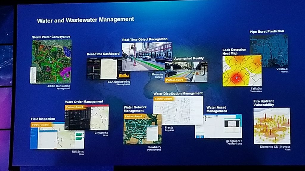
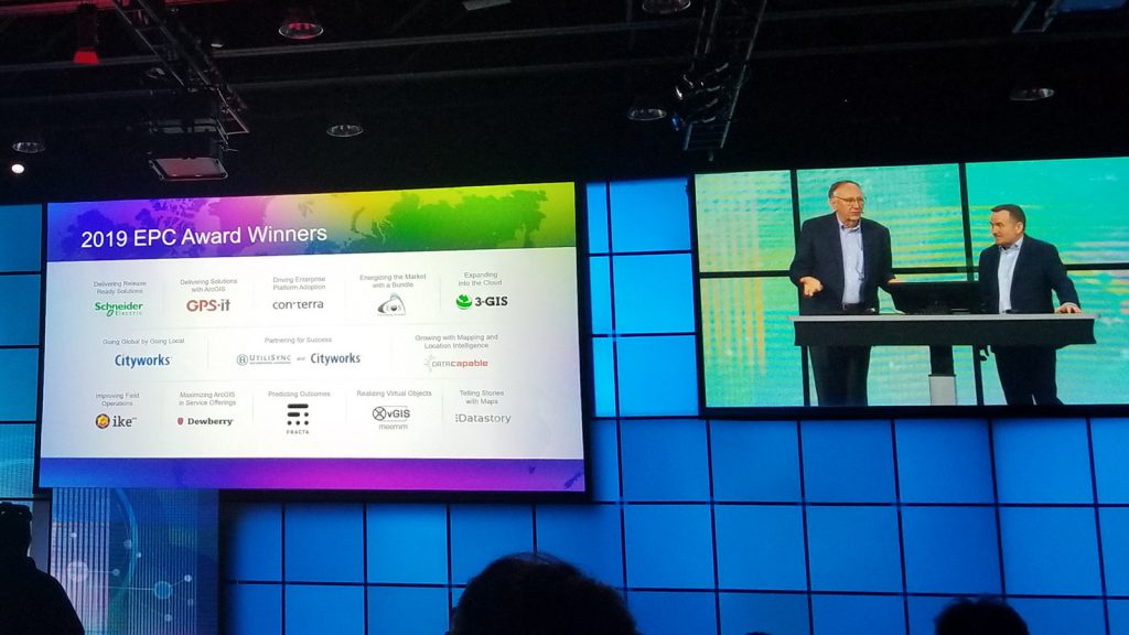
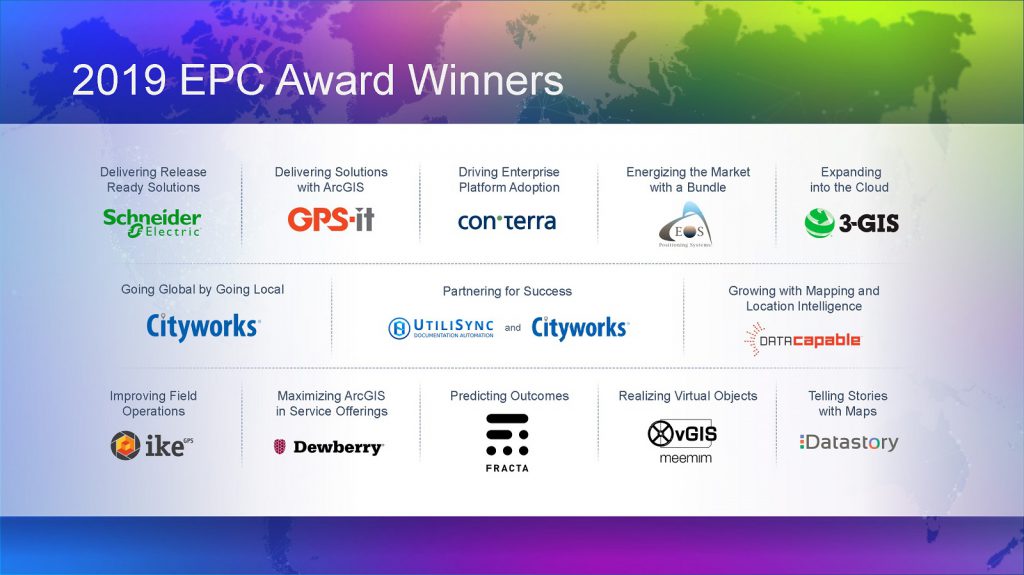
The awards, and the Esri partners being distinguished, include the following:
Delivering Release Ready Solutions Award—Schneider Electric provides digital transformation of energy management and automation in homes, buildings, data centers, and infrastructure.
Delivering Solutions with ArcGIS Award—GPS-it is an established aerial farm mapping and software development company, providing high-quality customized geospatial solutions.
Driving Enterprise Platform Adoption Award—con terra integrates Geo-IT into business processes across entire organizations in a diverse set of markets.
Energizing the Market with a Bundle Award—Eos Positioning Systems provides affordable, high-accuracy Global Navigation Satellite System (GNSS) receivers for use with any device, offering real-time positioning that integrates with mobile workflows.
Expanding into the Cloud Award—3-GIS develops and delivers cloud-based fiber network management solutions to support all parts of the value chain of planning, designing, building, managing, and knowing fiber networks.
Going Global by Going Local Award—Cityworks | Azteca Systems builds and delivers solutions that help organizations maintain smart, safe, and resilient communities by streamlining the care of public infrastructure and property, as well as permitting processes.
Growing with Mapping and Location Intelligence Award—DataCapable offers unique solutions for event detection, interactive maps, analysis, and outreach for organizations of all sizes and sectors to engage digital customers.
Improving Field Operations Award—ikeGPS Group provides a smart laser measurement solution for geospatial applications, allowing users to measure objects such as building features, signage, environments, disaster sites, and natural features simply by capturing a photo.
Maximizing ArcGIS in Service Offerings Award—Dewberry leverages deep subject matter expertise and technology to deliver innovative services to solve complex challenges and transform communities.
Partnering for Success Award—UtiliSync and Cityworks | Azteca Systems collaborate to deliver complementary work order and documentation solutions to meet the needs of fieldworkers and asset managers.
Predicting Outcomes Award—Fracta uses machine learning to deliver advanced analytics through a software-as-a-service (SaaS) solution to assess complex issues such as the Likelihood of Failure (LOF) in a water main pipe segment.
Realizing Virtual Objects Award—Meemim empowers users to experience virtual objects as if they were part of the real world by combining GIS technology with augmented reality to display infrastructure (pipes, lines, cables, and other assets) in the field and in real time.
Telling Stories with Maps Award—Datastory helps businesses make better decisions, offering sophisticated data analysis and insight and combining this with narrative text and images to harness the power of maps and geography.
The Esri Partner Network is an ecosystem of organizations working together to ensure the continued success of customers using the ArcGIS platform. Esri partners offer products and services that range from configured apps to COTS products and custom-built solutions, to complete ArcGIS enterprise implementations that help customers realize the potential of location intelligence technology.
The Esri Partner Conference was held March 2–4 at the Palm Springs Convention Center. The conference is an annual gathering where members of the partner community collaborate and network, hear about Esri’s vision and new opportunities, build business relationships, learn from Esri experts, and discover the latest technology and solutions in the GIS field.
To learn more about the Esri Partner Network, visit esri.com/en-us/about/esri-partner-network/overview.
About Esri
Esri, the global market leader in geographic information system (GIS) software, location intelligence, and mapping, offers the most powerful geospatial cloud available. Since 1969, Esri has helped customers unlock the full potential of data to improve operational and business results. Today, Esri software is deployed in more than 350,000 organizations including the world’s largest cities, most national governments, 75 percent of Fortune 500 companies, and more than 7,000 colleges and universities. With its pioneering commitment to geospatial information technology, Esri engineers the most advanced solutions for digital transformation, the Internet of Things (IoT), and advanced analytics. Visit us at esri.com.
Copyright © 2019 Esri. All rights reserved. Esri, the Esri globe logo, ArcGIS, The Science of Where, esri.com, and @esri.com are trademarks, service marks, or registered marks of Esri in the United States, the European Community, or certain other jurisdictions. Other companies and products or services mentioned herein may be trademarks, service marks, or registered marks of their respective mark owners.