Rail networks are among the most complex infrastructures in the world, stretching across vast distances and operating under strict safety and maintenance demands. As these systems age and expand, the challenge of monitoring assets, predicting failures, and coordinating maintenance grows exponentially. Increasingly, rail operators are turning to geographic information systems (GIS), LiDAR, and digital twin technologies to meet these challenges with precision and efficiency.
Beyond Mapping: Smarter Asset Intelligence
Traditionally, GIS served as a powerful mapping tool to visualize tracks, rights-of-way, and supporting infrastructure. Today, its role is expanding into real-time analytics and predictive modelling. By combining GIS with LiDAR and AI, railways can move beyond simple asset tracking toward dynamic, data-driven insight.

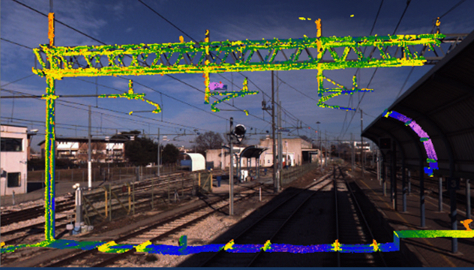
For example, network-wide LiDAR scans can generate detailed 3D models of tracks, switches, and bridges. When processed through GIS platforms, these datasets allow engineers to detect small structural shifts or vegetation encroachment that may signal early-stage risks. Combined with AI-based pattern recognition, this approach supports proactive maintenance scheduling and reduces costly downtime.
Real-Time Insights and Predictive Maintenance
Machine learning is also helping railways spot potential failures before they occur. By training models on years of inspection imagery and sensor data, operators can predict where rail fatigue, ballast instability, or component wear are most likely to happen. Front-mounted cameras, drones, and automated inspection cars now feed continuous streams of spatial data into GIS environments, turning static maps into living systems that evolve with every trip.
In emergencies or weather-related disruptions, mobile GIS tools provide immediate access to real-time and historical data. Field crews can visualize underground utilities, nearby hazards, and infrastructure conditions directly on mobile devices, enabling faster, more informed responses.
Building the Foundation for Digital Twins
As rail organizations modernize, many are layering GIS and LiDAR data into digital twins—virtual replicas of their physical networks that combine engineering models, point clouds, and live sensor feeds. This integration is helping companies simulate maintenance scenarios, test construction impacts, and forecast equipment performance before deploying field teams.
For example, Network Rail in the UK is using digital twins to monitor bridges and tunnels, comparing new scans against baseline data to identify early signs of wear. In Japan, East Japan Railway Company has begun integrating LiDAR and AI to create digital models of stations and track corridors, improving both safety inspections and accessibility planning. In North America, several Class I rail operators are developing corridor-wide twins that link LiDAR and drone data with inspection records, giving planners a real-time view of network health across thousands of miles.
Ultimately, these digital twins act as living databases that grow more accurate with each scan or field update. They unite planning, maintenance, and operations in one spatially aware environment, making it easier to prioritize repairs, allocate resources, and maintain safety at scale.

Connecting to vGIS
At vGIS, we help organizations bridge the gap between data and decision-making. Our augmented reality and LiDAR-based visualization tools bring complex geospatial information directly into the real world, allowing field teams to see underground utilities, infrastructure, and asset data overlaid precisely where they stand.
As railways move toward smarter, data-driven operations, the combination of GIS, LiDAR, and AR visualization is redefining how they manage safety, reliability, and efficiency. From predictive analytics to immersive digital twins, this transformation is already underway—and the railways leading it are shaping the future of connected infrastructure.