
Several kilometres of combined sewer needed replacement beneath a four-lane road in mid-town Toronto. For Green Infrastructure Partners (GIP), the job ran through one of the city’s busiest underground utility corridors.
Crews had to work around buried infrastructure, keep construction moving, and document each installation. At the same time, the team needed a dependable record for engineers, reviewers, and future handovers. GIP brought in vSite to connect those tasks. The platform helped crews capture information while the ground was still open, rather than trying to rebuild the story later.
The challenge: work you cannot always see
Design drawings did not always show what was underground. Existing utility records were incomplete, and unexpected conflicts could stop excavation. For example, a buried line could cross the planned location of a manhole. The crew would then need to confirm the issue and send evidence to the designer. Meanwhile, traditional as-built surveys often followed construction by weeks. By that point, trenches were already covered and important details were harder to verify.
That delay made handovers harder. Photos and field notes could also end up in different places, outside the main project record. As a result, engineers spent more time piecing together what happened. It also raised a bigger concern: what happens if another contractor damages a newly installed pipe after GIP leaves? Without a clear record of its condition, responsibility can be difficult to establish.
Six ways GIP used vSite in the field
1. Capture digital as-builts during installation
Crews recorded pipes and manholes as they went in, instead of waiting for a return survey visit. Surveyors still set the initial control points and checked quality. However, field crews handled routine digital as-built documentation, so records stayed closer to the work. That reduced repeat survey trips. It also gave the office a more current view of completed installations.
2. Scan open trenches before backfilling
Superintendents used LiDAR-equipped iPhone Pro or iPad Pro devices to scan exposed infrastructure. vSite turned those captures into location-linked 3D records, including meshes and point clouds. The crew could capture the trench before backfilling, when pipes and surrounding conditions were still visible. As a result, the team could review what crews installed even after the trench was closed. Learn more about 3D trench scanning.
3. See utility conflicts before digging
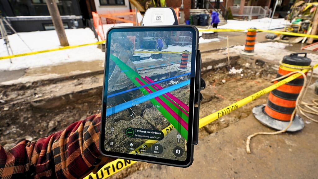
vSite displayed colour-coded design lines and captured utility data in augmented reality (AR). Instead of switching between drawings and the trench, crews could view the information in context. This helped them compare planned work with site conditions and spot possible conflicts sooner. They could also check whether the design matched what they uncovered. For a congested urban corridor, that extra context supported better utility damage prevention decisions.
4. Keep stakeouts moving
Once surveyors set primary control, GIP forepersons could place stakeout offsets using vSite. They no longer needed another survey visit for every routine offset. That flexibility mattered when crews worked evenings or weekends. It also helped the team keep excavation moving as the work area changed. Surveyors could then focus on initial control and periodic quality checks.
5. Keep evidence ready for a claim
vSite stored scans, photos, and notes with location, direction, and time information. Each record provided context about what crews saw and when they saw it. Therefore, the team could retrieve evidence of a completed installation instead of searching through unrelated photos or paper notes. That made the records useful for handovers and possible claims.
6. Share one current project record
Scans, redlines, and as-built data synchronized to vSite Web in near real time. Field crews, office engineers, city reviewers, and utility owners could access the same information. In addition, engineers could review evidence of utility conflicts while crews were still on site. This made it easier to address questions without waiting for separate photo packages or another site visit.
The real test came after handoff
A telecom subcontractor damaged a lateral after GIP had left the site. The repair charge could have landed on GIP, even though another crew caused the damage. Fortunately, the team had time-stamped vSite scans showing that the pipe was intact at handoff. The evidence established the pipe’s condition when GIP completed its work.
Those records helped protect GIP from the charge. The incident showed the value of capturing evidence before it is needed, not after a dispute begins. It was more than a digital filing exercise. The same field record that supported construction also helped resolve a question about liability. Our article on construction field documentation explores why those gaps matter across the industry.
What changed, and what comes next?
GIP reported fewer utility near-misses, earlier design checks, and faster as-built documentation. Engineers also received 3D evidence of conflicts within the same shift. This helped them review issues before they became longer delays. Meanwhile, crews had a simpler way to record everyday work. Together, those improvements gave the project a clearer record and supported faster decisions.
These are qualitative findings from supervisors and field teams, not measured ROI figures. Still, the experience gave GIP a practical reason to expand vSite to more sewer and water main projects. The planned expansion includes smaller tie-ins as well as complex, multi-year road work.
The takeaway is simple: when crews capture accurate records during construction, the information remains useful for coordination, closeout, and future claims.
Want to see how vSite could work on your next utility project?
