
A few weeks ago, a car lost control near my neighborhood and struck an electrical transformer box on the street. Within minutes, several homes went dark. Utility crews arrived quickly, worked through the evening, and had power restored within a few hours. By the next morning, the transformer looked good as new, as if nothing ever happened.
But beneath the surface, this kind of incident leaves a footprint that can quietly cause data quality problems for years.
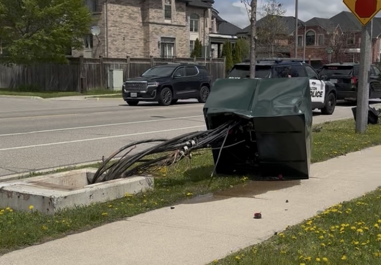
When Speed Becomes the Priority
Emergency utility repairs are, by nature, reactive. A transformer gets hit, a water main bursts, a gas line gets nicked during unrelated excavation work. Crews are dispatched under pressure, the clock is ticking, and the focus is entirely on restoring service as fast as possible, which is exactly how it should be.
The problem is what happens to documentation during that process. In the urgency of the moment, recording the precise location of a replaced component, logging a rerouted line, or updating asset records becomes a secondary concern. Often it gets deferred, or sometimes it gets skipped entirely.
In isolation, one undocumented repair is a small gap. But utilities and municipalities manage infrastructure that spans hundreds of kilometers, and emergencies happen constantly. Multiply a single documentation gap by hundreds or thousands of repairs over decades on aging infrastructure, and the cumulative effect becomes significant. The official records show a utility network that no longer matches what is actually in the ground.
How Data Drift Creates Downstream Risk
Inaccurate utility records carry real safety consequences that extend far beyond paperwork.
When a contractor calls for locates before breaking ground on a new project, those locates are only as reliable as the underlying data. If a water main was rerouted three years ago during an emergency and that change was never properly recorded, the locate reflects the old position. The excavator proceeds with confidence, and the crew ends up dangerously close to, or through, infrastructure that was not supposed to be there.
This kind of utility strike can injure workers, cut service to businesses and homes, and result in costly project delays and liability exposure. The frustrating part is that the hazard was created not by negligence during the repair itself, but by a documentation gap that accumulated quietly over time.
Where GIS and AR Technologies Can Help
Modern GIS platforms and augmented reality tools are well-suited to address both sides of this problem: reducing the data gaps that emergencies create, and improving the accuracy of field decisions made from existing records.
On the documentation side, GIS-integrated mobile workflows allow field crews to capture and submit location data in real time, even during emergency response. Rather than relying on someone to file paperwork after the fact, a technician can record a GPS-tagged repair directly from the field with minimal added effort. That data flows into the central asset management system immediately, closing the gap before it has a chance to grow.
On the field side, AR technology allows crews and contractors to visualize utility data overlaid directly onto the physical environment. Instead of interpreting a two-dimensional drawing or a marked line on the ground, a worker using an AR-enabled device can see the mapped location of buried infrastructure in context with what is actually in front of them. That spatial awareness makes it far easier to identify discrepancies between records and reality, and to flag them before the next crew makes a potentially costly assumption.
A Small Incident with a Larger Lesson
The transformer strike near my home was a minor event in the grand scheme. Power came back, the equipment was replaced, and life moved on. But it was a useful reminder that every emergency repair is a moment where real-world conditions diverge from the official record, even briefly. Over a long enough timeline, those moments add up.
The construction and utilities industries are under increasing pressure to reduce risk and improve the accuracy of their data. GIS and AR technologies will not eliminate emergency repairs, but they can substantially close the gap between what crews do in the field and what the records show afterward. That is a straightforward investment with meaningful long-term returns in safety and efficiency.
